As a first blogpost, I’ll introduce myself a bit. I’m a transportation planner from the U.S. focusing on sustainable urban transportation, and thanks to the help of a lot of people I was accepted into the Robert Bosch Foundation Fellowship Program. It started with German courses in Berlin, then a three week seminar learning about major topics in Germany and the EU, from Stuttgart 21 to Syrian refugees to the future of the Euro. Over the course of the next year, I’ll have two work placements related to transportation planning, the first with the Hamburger Verkehrsverbund (HVV), the regional transit organization. I wanted to show that Germany’s contribution to transportation isn’t just the Autobahn, but a whole wealth of innovation that helps cities increase the quality of life of their residents, their economies and their sustainability.
Since I just moved to Hamburg last weekend, I haven’t started with the HVV yet, so I wanted to give some impressions on customer information at bus stops from Berlin. This isn’t electronic, no apps, no computer displays (although many have them), just paper. This simple information at each stop makes it very easy to use transit in a new city, or even to use a new line if you’re already familiar with the city.

This is standard at every bus shelter in Berlin: a real street map of a wide radius around the bus stop (in the U-bahn (subway) stations they have the entire map of Berlin) showing bus lines, tram lines, U-bahn lines, and S-bahn lines (between a subway and a commuter rail), and of course their corresponding stops. This is especially important with buses as most bus maps in the US leave out the stops. The road map, which is put out by the transit agency itself (and so it emphasizes the transit network) is also useful to people not taking the bus, like when I’m lost looking for someone’s house or just biking around on a nice day.
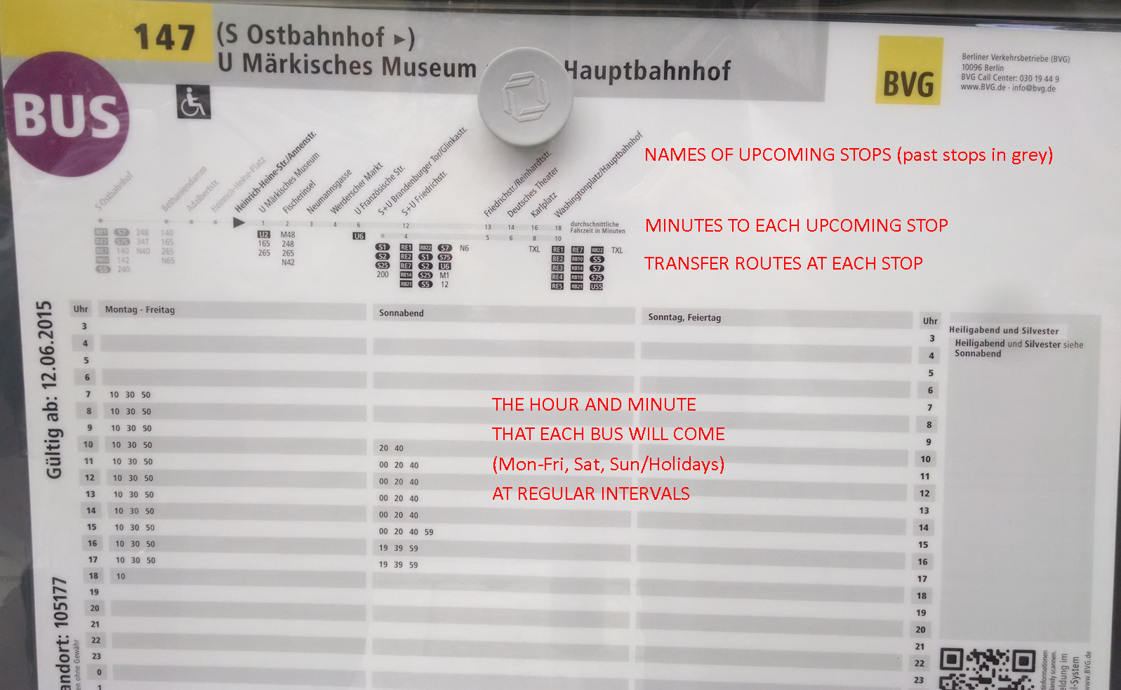
The schedule below the map shows the entire route’s stops at the top, including how many minutes to travel to each stop and which routes to transfer to (not just major transfer routes, but all routes). It also shows previous stops in gray. The bottom section shows each hour of the day per row, and each column (Monday-Friday, Saturday, and Sundays/holidays) shows the minutes after the hour that each bus comes, so in this case it is 10, 30, and 50. This means that even though this bus only runs every 20 minutes, I can easily know exactly when the bus will come by remembering 3 easy numbers (10, 30, and 50) so I’m never waiting for 20 minutes. Of course the bus was late a couple times, but for the most part this schedule was accurate.
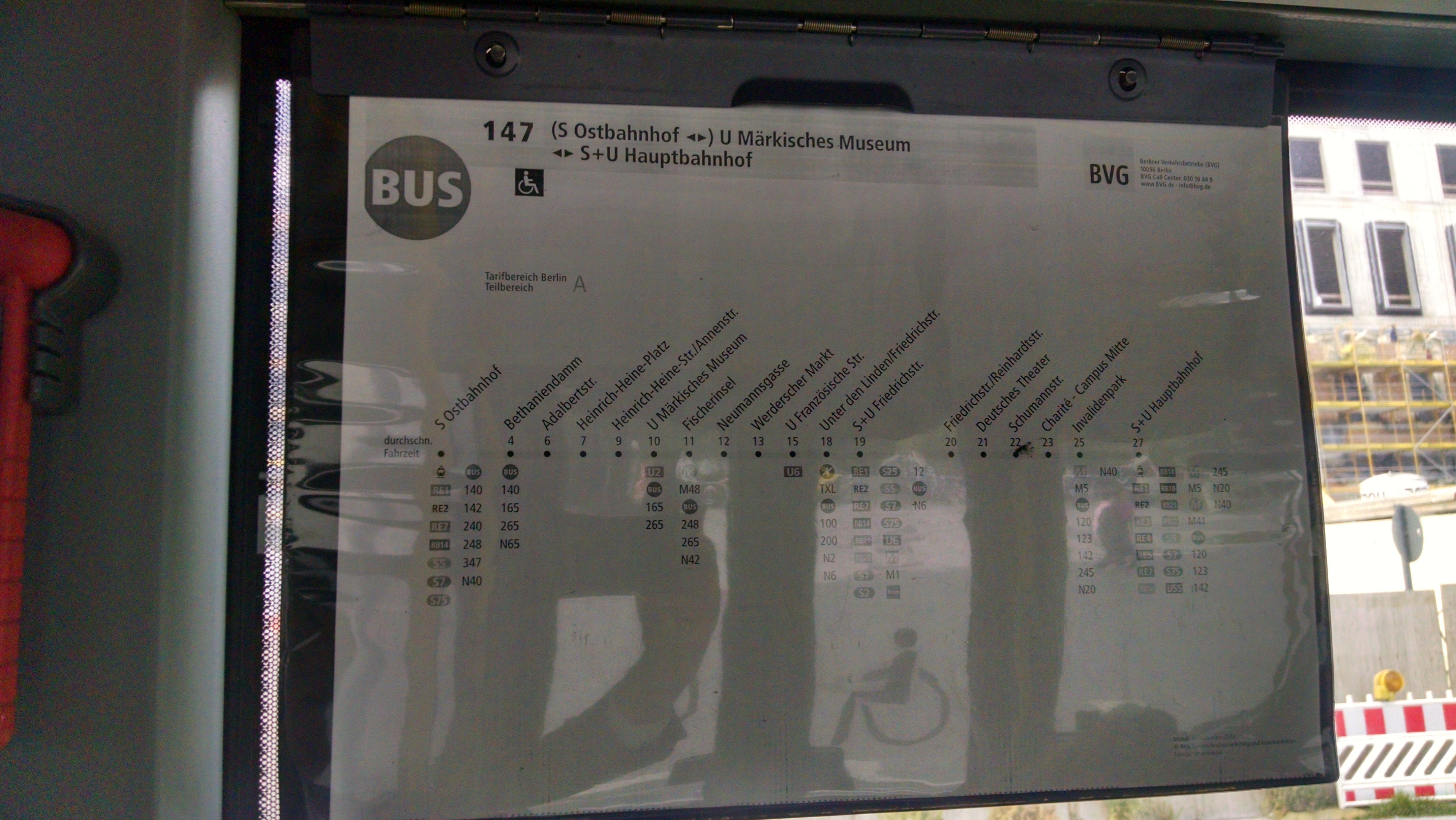
Then, once I’m in the bus, there is a list of the entire route taped to a window, so if I’m unsure how many more stops I have, I can just look at this. Also notice that it shows how many minutes from the starting point (and between stops, with a little ‘rithmatic) and the transfer routes.

To show a schedule with a higher frequency, this tramline’s headway is 10 minutes most of the day, but exactly 10 minutes, so a passenger would only need to remember one number, in this case 3 (because the tram comes 3, 13, 23, etc. minutes past the hour).
Even though this information is not online (although by now it is), one can easily navigate a new transit system with simple and clear information and headways.

Leave a comment